
Hurricane Dorian update Sept 1st-11 am.
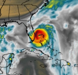
At 11am Hurricane Dorian now has maximum sustained winds of 180 mph and moving a bit slower at 7mph heading West. This is a MONSTER of a storm, a very strong Cat 5 Hurricane. May God bless those affected in the Bahamas. This will be catastrophic.
The storm will continue to slow down and this will be devastating for the Bahamas. Dorian is expected to sit over the Northern Bahamas for 24-48 hrs. Again my thoughts and prayers to those in the Bahamas.
The slower speed should mean that a gradual turn to the North will begin over the next 24-30 hrs or so. When and where that turn begins will be KEY to our impacts on the SE Florida area.
There are now Hurricane watches issues from Deerfield Beach to Brevard/Vousia county line.
A Tropical storm watch is still in effect for all of Broward county and now also includes Lake Okeechobee.
As the storm grows so does the wind field. Hurricane force winds now extend out 45 miles from the center and Tropical storm force winds now extend out 140 miles from the center of circulation.
The trending has been a bit West and a bit South over the last 12 hrs which is why all the new watches and warnings.
As I have been saying non stop we ALL need to monitor Dorian very closely as by Tuesay morning it is forecast to be just off shore in the Palm Beach area. Any wobble to the South and to the West and all of us in SE Florida will experience higher winds and rains.
As if now I still expect TS conditions for most of Broward and some TS squals in Miami Dade. Again this is very fluid and things can and will change over the next few days.
OG
THEOGDAILYBUZZ.COM
