Potential Tropical Cylone Humberto-Sept 13th-11 am

11am update on Potential Tropical Storm Humberto.

A few of you have asked me my opinion on the storm so here’s a quick update.

The “Potential” Tropical Storm is still only a Tropical wave. It is expected to become a Depression/TS over the next 24-36 hrs or so.

It is over the Bahamas and expected to move NW and be close to the Central Florida coast, Melbourne area sometime Saturday evening as a Tropical Storm.

There is a TS watch from Jupiter Inlet to Flagler/Volusia county line. Very similar to Dorians path last week.

For those of us in SE Florida we should continue to see the same weather we have been having the last few days, a bit windy, with quick passing showers, nothing to be concerned about at all.

The storm will then head towards the Jacksonville coast by Sunday mid day and then hug the coast through SC before hopefully heading out to sea.

It may become a Hurricane once it’s out to sea, but at this point in time it should stay as a TS along the SE coast of the US. Some high surf, minor storm surge, wind and rain, but shouldn’t be too bad.

This is nothing close to Dorian, thank God!

I don’t plan on posting any other updates on this storm unless something changes with the forecast in the next day for so.

Have a great weekend!

THEOGDAILYBUZZ.COM

Hurricane Dorian update: 4pm Sept 2nd

Hurricane Dorian 5pm update-Sept 2nd

Hurricane Dorian continues

to pound the NW Bahamas, Grand Bahama island at this time with winds of 145 mph with higher gusts .

Dorian is currently stationary which is terrible for the Bahamas. The storm is expected to begin a Western movement again later tonight and more of a WNW movement tomorrow during the day and then a NW movement during the evening hours of Tuesday night.

We should hopefully start seeing that North Eastern turn sometime on Wednesday afternoon. The question is where Dorian be in relation to Florida’s East coast when it makes that turn? Right now the best guess is somewhere just off shore or just onshore of the Jacksonville area as still a Major Hurricane.

Every on the East coast of Florida North of Palm Beach has to watch and monitor Dorians path very closely as you have been doing.

We then need to focus on Ga, SC, NC and hopefully it will then stay off shore and GO AWAYonce and for all!

The worst of what we will experience in Miami Dade and Broward counties will start occurring this evening into tomorrow. Some of you may have already experienced some TS squals, where it pours for a few minutes and winds pick up and then it clears up. We will see more of these squals in some of our areas just more frequently. Nothing major. We have have a few smaller trees down and sporadic power outages, but I don’t expect much damage in Dade and Broward counties. Tonight and most of tomorrow will be crappy so stay home if you can. Nothing major but equally weather.

I would expect more power outages and some widespread damage from Palm Beach and points North especially along Floridas East coast.

Remember if you happen to be North of the Hurricane and to it’s West, like Jacksonville for example, and you live along the coast you will have Storm Surge. Storm surge causes more deaths in hurricanes than anything else. The wind will be coming in from the East or NE depending on where you live.

Please be safe and I will post updates as necessary.

I have also posted a flyer with some Hurricane relief efforts for our friends in the Bahamas. Let’s ALL pitch in as they are going to need help big time.aftwr the storm passes.

If you want to share any of your relief efforts please send to me tag me on your post. The more options the better!

Thank you! OG

THEOGDAILYBUZZ.COM

Hurricane Dorian Intermediate Advisory-Sept 2nd-8am

Hurricane Dorian Intermediate Advisory- Sept 2-8am

At 8am Hurricane Dorian is still a Cat 5 Hurricane with winds ar 165 mph.

The biggest difference between last night and this morning is the forward speed of Dorian.

Dorian is now barely moving, almost stationary Moving West at 1mph

This massive storm continues to pound the NW Bahamas. It’s currently just sitting over Freetown in Grand Bahama. My thoughts and prayers are with those on the Bahamas.

The peak winds (Some TS Force gusts in squals) and rain for Dade and Broward should be later today through midday tomorrow afternoon. I anticipate things getting much better tomorrow evening for Dade and Broward.

Thise from Palm Beach North and all the way up the coast of Dlorida, Ga, SC, and NC need to continue to monitor Dorian very closley.

Dorian will be VERY close to the Florida East coast over the next few days as it hugs the coast.

A TS Watch is in effect for Broward, TS warning in Palm Beach, Hurricane warnings and watches all the way up to Jacksonville.

There are also Storm Surge warnings for North of Deerfield Beach of 2-7ft.

To put this in perspective compared to our friends in the Bahamas. Grand Bahama is currently experiencing Storm Surge of up to 23 Ft!! Again, this is going to be catastrophic for the NW Bahamas.

In closing please keep watching and stay prepared especially for Palm Beach North. In Dade and Broward we will see some TS squals especially later today and tonight but we are mostly going to miss most of Dorians fury.

After Dorian leaves the Bahamas we ALL need to do whatever it takes to help our neighbors in the Bahamas. They will be needing our assistance for many months.

I have already been in discussions with a few people who are organizing relief efforts for the Bahamas and I will post here and on my Blog at THEOGDAILYBUZZ.COM.

Thank you.

OG

Hurricane Dorian update: Sept 1st- 5pm.

Hurricane Doriane update: 5pm Sept 1st.

Hurricane Dorian continues to to unleash it’s wrath on the Northern Bahamas.

Dorian currently has max sustained winds of 185 mph with gusts over 220 mph and now only moving West at 5 mph, which is catastrophic for our friends in the Bahamas. This is the stro

ngest Hurricane EVER recorded in the Bahamas.

Most watches and warnings in South Florida remain the same. There is now a Hurricane warning from Jupiter inlet to the Brevard/ Volusia county line.

Broward county is still under a Tropical Storm watch.

We are still anticipating a Northern turn over the next 24hrs. This turn WILL occur due to a strong trough digging in from the West to the East Coast of the United States, plus a weakening in the high pressure system that has been steering Dorian over the past week or so.

The question with this storm is timing. If the trough takes a bit longer to pull Dorian North then Dorian will make landfall over Florida before heading North. This is still not likely, but it is possible. At this point this scenario can’t be discounted.

This storm will then hug the coast and possibly make it all the way up to Virginia as still a Hurricane. Think about this, after nailing the Bahamas, and Impacting Florida this Hurricane will still have enough strength as it goes up the East coast effecting Fl, Ga, SC, NC, and Va and it will possibly still be a Cat 1 hurricane by the time it reaches Virginia sometime on Friday the 6th of September! Insane!

This storm will go down in history as one of the strongest, most catastrophic and costliest hurricanes in the record books.

Let’s continue to pray for our friends in the Bahamas who are going through a devastating Hurricane and they still have 24 hrs or so more to go before things calm down. May God bless them.

I will post an update at 11pm if anything changes, if not first thing in the morning.

Please keep monitoring this blog or your local news as things can and will change again.

OG

THEOGDAILYBUZZ.COM

Hurricane Dorian update-Sept 1st-11am

Hurricane Dorian update Sept 1st-11 am.

At 11am Hurricane Dorian now has maximum sustained winds of 180 mph and moving a bit slower at 7mph heading West. This is a MONSTER of a storm, a very strong Cat 5 Hurricane. May God bless those affected in the Bahamas. This will be catastrophic.

The storm will continue to slow down and this will be devastating for the Bahamas. Dorian is expected to sit over the Northern Bahamas for 24-48 hrs. Again my thoughts and prayers to those in the Bahamas.

The slower speed should mean that a gradual turn to the North will begin over the next 24-30 hrs or so. When and where that turn begins will be KEY to our impacts on the SE Florida area.

There are now Hurricane watches issues from Deerfield Beach to Brevard/Vousia county line.

A Tropical storm watch is still in effect for all of Broward county and now also includes Lake Okeechobee.

As the storm grows so does the wind field. Hurricane force winds now extend out 45 miles from the center and Tropical storm force winds now extend out 140 miles from the center of circulation.

The trending has been a bit West and a bit South over the last 12 hrs which is why all the new watches and warnings.

As I have been saying non stop we ALL need to monitor Dorian very closely as by Tuesay morning it is forecast to be just off shore in the Palm Beach area. Any wobble to the South and to the West and all of us in SE Florida will experience higher winds and rains.

As if now I still expect TS conditions for most of Broward and some TS squals in Miami Dade. Again this is very fluid and things can and will change over the next few days.

OG

THEOGDAILYBUZZ.COM

Hurricane Dorian update: Sept 1st 8am

Hurricane Dorian 8am Advisory Sept 1st.

Dorian is now a Cat 5 Major Hurricane with winds at 160 mph. Dorian is still moving West at only 8 mph. The forward speed should slow down further as it starts making the turn NW and then eventually North.

The latest cone has shifted South and West closer to us in Florida hence the new TS watches and warnings. While the storm is still “expected” to remain offshore we can’t let our guard down until we start seeing the “turn”. Please just keep monitoring updates just in case.

Dorian will be over the Bahamas until Tuesday morning. This is terrible for our friends in the Bahamas as they will be hit hard by this monster for nearly 36 hrs. May God bless them.

There is now a Tropical Storm watch from Golden Baeach in NW Miami Dade county and in Broward County. TS warnings are now from Deerfield Beach to Sebastian inlet.

Next full advisory is at 11am.

OG

Hurricane Dorian update: Aug 30th 5pm

There has been a lot of shifting of the models from North to South and now North again over the past 24 hrs.

Dorian is currently moving WNW at only 9 mph with max sustained winds of 115 mph, which is a Cat 3.

The latest European model and American GFS model have both been trending North most of the day today which is great news for Dade, and Broward counties, not so much for Palm Beach and points North. However this can and will probably change a few times prior to land fall.

What’s causing the changes in the projected track? The speed of the storm is actually helping South Florida at ” this point in time”.

By the storm slowing down it is allowing the High Pressure ridge I’ve been talking about all week to move West towards Florida and then retreat a bit to the East. There will be a window where the stearing currents aloft will be weak. This will allow the upper level winds that blow from West to East accross the US to “possibly” catch Dorian and move it North, and then North East where the High pressure will leave a gap. Think of a “tunnel” in the atmosphere and the storm taking that tunnel and following its path.

I have been pretty consistent in predicting a Palm Beach, North Palm beach landfall and then having Dorian heading North, North East after land fall. I am not 100% confident but I feel this is the most likely scenario. This is only my opinion that is based by me reviewing many model runs and current atmospheric conditions, and not etched in stone by any means.

As of now the models are showing landfall around Palm Beach as well, along the Jupiter area and then hugging the coast all the way up to Jacksonville.

The main problem with this forecast is that the storm will still be able to tap into the warm waters of the Atlantic being so close to the shore. Another issue is the SLOW movement of Dorian and the amount of rain it will drop in its path.

The latest NHC timeline has Dorian making landfall around 2pm on Tuesday as a Cat 3 or 4 and it will still be in Florida between Central Florida and Jacksonville on Weds at 2pm as a Cat 2. This is little movement in 24 hrs and not much decrease in intensity. This could be catastrophic for this part of Florida, a tremendous amount of rain can fall in this area and major flooding can be expected.

I still expect Tropical Storm force winds for all of South Florida with higher gusts unless we get really lucky and Dorian stays off shore right before arriving in Florida.

This storm is relatively small in size “Diameter” which helps. As of now Hurricane force sustained winds extend out between 25-30 miless from its center. Take where you live and go North 25-30 miles if you are in SE Florida and mark that point. That point is where Dorian’s center would have to pass in order for your home to get sustained Hurricane force winds. The same thing with Tropical Storm force winds, except these extend out 100 miles. Most of us will have TS force winds using this formula regardless.

I would remind you that basically ALL of Florida is still in the cone and things can and will probably change again. We can’t let our guard down and just think that now that the models are trending North that we are out of the woods, we are not! We need to continue to prepare and plan as if we are going to have a direct hit by Dorian and hope that we don’t.

I will update again tomorrow and lets hope the Northern trends continue.

Below is the latest NHC cone, and European and GFS models

OG

Hurricane Dorian update: Aug 29th 5:00pm

There has been little change since my last update last night with Dorian in regards to it’s “current” strength and motion. There are some changes in regards to its future intensity and potential track. I will go into more detail below.

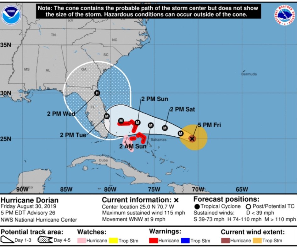
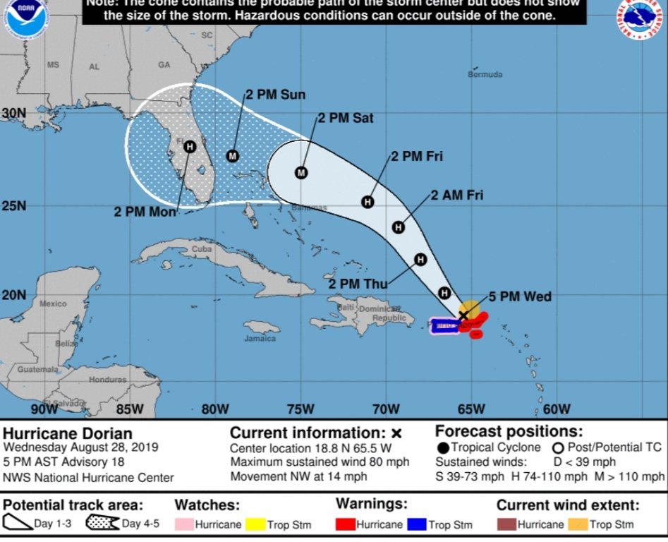
As of 5pm on Aug 29th the storm was still moving NW at 13 mph with maximum sustained winds at 85 mph. Nothing has changed since my last blog in regards to intensity and motion.

The biggest change is that the NHC is now predicting a Major Cat 4 Hurricane, which means max sustained winds of over 130 mph hitting Florida. Strengthening is expected to occur once the storm nears the North Western Bahamas sometime Sunday afternoon. All the ingredients are there for growth, very warm waters, low wind shear, and moist air aloft. The dry air that was inhibiting Dorians growth has moved away. The area is PRIME for development and will it will provide fuel for Dorian.

Another change is the forward speed of Dorian going forward. Dorian is now predicted to make landfall in Florida on Monday afternoon instead of Sunday as originally thought. The storm will be slowing down due to the stearing currents aloft or lack thereof.

I am more concerned about the forward speed and the ramifications of Dorian slowing down. The storm may “possibly” linger in the Central Florida area for 24-36 hrs dropping copious amounts of rain. Major flooding can be expected if this occurs.

I keep seeing all the memes on Social Media making light that no one really knows where this storm is going. This is correct, it can make landfall just about anywhere along the Florida East Coast up to Georgia. This is the main reason to keep paying attention to the forecast, this Blog or whatever source you rely on.

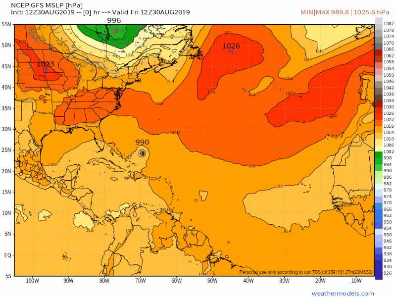
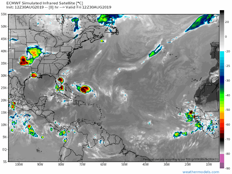
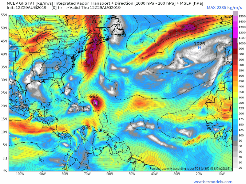
Right now the European model has it going slower and going further South, over Dade and Broward counties. The other reliable model GFS has it further North making landfall around Palm Beach, Vero Beach area and moving much faster.

I can say with confidence that we wll be impacted in Florida one way or another. Best case Tropical Strorm gusts and obviously worst case experiencing a Major Hurricane.

The key as I’ve been saying is the high pressure ridge and how far West it digs. The latest models have it going West over Florida and then retreating slightly East right after land fall.

What does this mean? The storm possibly making landfall in anywhere in SE Florida up to Melbourne area and then sitting and hanging out for a day or so in Central Florida before riding up the coast to Ga, SC and NC. This is a real possibility at this time. Flooding will be a major problem if this occurs.

Again, this is very fluid and Dorian has had a mind of it’s own and hard to forecast.

Please, please don’t focus on the center of the cone and that it’s only a Cat 1 storm ccurrently. This hurricane is small, but it will intensify and grow from its current state. It is currently going through an eye wall replacement which means it will intensify. This storm isn’t as large as Irma was in 2017 which is a good thing as the strong winds will be very con

centrated near the center, but Dorian will grow from it’s current state, this will happen.

I think that by tomorrow night, Friday Aug 30th we will have a lot better idea of where Dorian is headed. Until then, stay tuned, and prepare just in case!

Go buy your supplies, water, snacks, batteries, and has up your cars. Worst case you can always eat all those chips and snacks you purchased for the storm over the next few weeks since football season is upon us!!

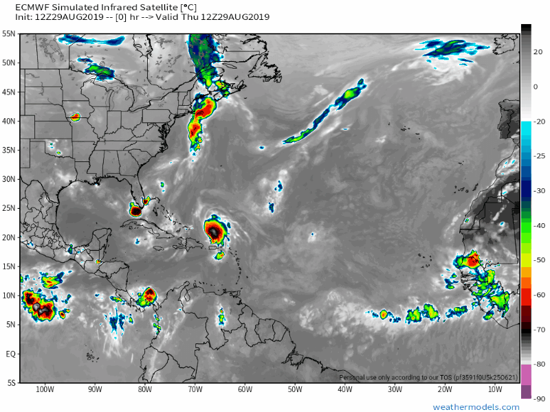
Please see latest European and GFS model runs below.

Stay safe and I will post updates tomoreos afternoon.

OG

Hurricane Dorian update’Aug 28th-6pm

A lot has changed with Dorian since my last post a few days ago, and most of the change is not good for those of us in Florida.

The first major thing to happen was that Dorian’s center of circulation reorganized about 50 miles NE from its original point from a few days ago.

What does this mean? It means that the now newly classified Cat 1 Hurricane’s core will miss most of Puerto Rico, and Hispañola and will remain over the very warm Atlantic waters which is fuel for the storm.

Another thing that is on the storms side is that the dry air that inhibited it’s growth the last few days has moved away. Also by moving its center NE the wind shear in the area is less than it was a few days ago, which is not good.

The developments over the last 24 hrs are pretty much worst case of all that could have happened with Dorian. A few days ago it was highly possible that the storm would be shredded by the mountains of PR and Hispañola and or the wind shear.

Now a few days later we are looking at a Cat 2 or possibly Cat 3 probably hitting somewhere along the Florida East coast, and possibly as far North as Ga, or SC or as far West as Alabama, and the Gulf of Mexico.

As of right now, and this has been a very difficult storm to track, it “appears” like the Melbourne area, North Palm Beach area all the way up to Jacksonville as the best guess for landfall, but this will probably change again over the next few days. The European model which is the most reliable model has Dorian coming onshore in the Palm Beach area. I’ll explain why the uncertainty below.

The key to Dorian’s track is a high pressure ridge that is moving West just ahead of the storm. How far West this High Pressure moves will dictate how much of a left turn into Flordia Dorian takes.

If the high moves West over Florida the storm will turn left much quicker. If the ridge stays further East the storm will follow the weakness and move further North, possibly into Ga, or even SC. I don’t see this happening as the ridge of high pressure is already starting to dig towards the West. I see Eastern Florida as the landfall point.

Again, a lot can change over the next few days but of you live in Florida, I would start preparing just in case.

In closing for those of us in Florida, we will probably experience some Tropical Storm conditions beginning late Saturday night and into Sunday and Monday depending on Dorians speed at the time. Hurricane conditions are possible and probable close to where Dorian makes land fall which is still too difficult to predict at this time.

You will never recieve Hype and Wishcasting on this Blog. I will only give you the facts based on the data provided and my “opinion ” based on this data.

This storm is very hard to track so please make sure to keep watching your local weather sources and of course reading this blog for updates.

Please see latest NHC cone and European model run.

I will post updates again tomorrow.

Thank you and stay safe!

OG

Tropical Storm Dorian

Many of you know that one of my true passions is the weather and especially tracking Tropical Cyclones.

So far the 2019 Hurricane season has been extremely quiet. It’s been one of the least active August’s on record.

However, as they say all good things must come to an end.

Dorian is churning out in the Atlantic Ocean as a small Tropical Storms with winds at 60mph moving WNW. Some strengthening is expected over the next few days as the storm approaches Puerto Rico as a Cat 1 Hurricane.

After the storm leaves Puerto Rico is when the uncertainty in the forecast begins.

As of now the Tropical Storm or minor Hurricane is expected to follow a strong high pressure system to it’s North.

At this time it looks like Dorian will go over North Eastern Hispañola and miss most of the higher mountains.

The system should be weaker and be heading towards the Bahamas as a Tropical Storm by Friday Aug 30th and Sat Aug 31st.

The question right now is does Dorian intensify over the very warm waters between the Bahamas and SE Florida? There is a low pressure system that will be digging South as Dorian approaches the Bahamas and this will have an effect on Dorians intensity and path.

Right now “MY” best guess and projection is either a strong Tropical Storm or Cat 1 Hurricane hitting SE Florida, anywhere from Miami to Palm Beach over the Labor Day weekend, most likely late Saturday night into Sunday morning.

I don’t see a Hurricane stronger than a Cat 1, but these storms have been known to blow up and anything can happen.

I would advise all of my friends in Florida, especially South Florida to be prepared just in case.

This is a good time to have your Hurricane preparedness ready and not wait until the last minute.

There is no need to put up your shutters or anything of that nature, just have your Hurricane plan ready to execute just in case.

Again, I don’t anticipate a large storm at this time, but I do expect a Tropical Storm or Cat 1 Hurricane in our general vicinity sometime this weekend.

Hopefully the mountains and upper level winds tear Dorian up and all we have is some rain and a few gusty winds in South Florida this weekend.

I have attached the latest NHC cone and a few models I use for tracking that I trust.

I will keep updating this Blog for updates on Dorian on a daily basis.

OG