A lot has changed with Dorian since my last post a few days ago, and most of the change is not good for those of us in Florida.
The first major thing to happen was that Dorian’s center of circulation reorganized about 50 miles NE from its original point from a few days ago.
What does this mean? It means that the now newly classified Cat 1 Hurricane’s core will miss most of Puerto Rico, and Hispañola and will remain over the very warm Atlantic waters which is fuel for the storm.
Another thing that is on the storms side is that the dry air that inhibited it’s growth the last few days has moved away. Also by moving its center NE the wind shear in the area is less than it was a few days ago, which is not good.
The developments over the last 24 hrs are pretty much worst case of all that could have happened with Dorian. A few days ago it was highly possible that the storm would be shredded by the mountains of PR and Hispañola and or the wind shear.
Now a few days later we are looking at a Cat 2 or possibly Cat 3 probably hitting somewhere along the Florida East coast, and possibly as far North as Ga, or SC or as far West as Alabama, and the Gulf of Mexico.
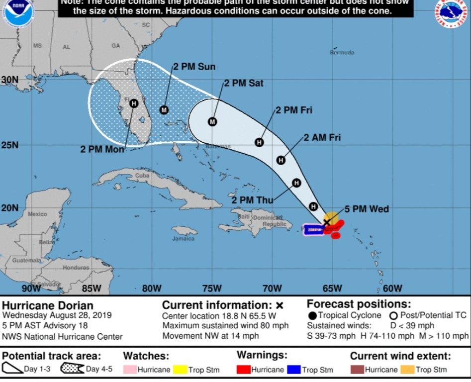
As of right now, and this has been a very difficult storm to track, it “appears” like the Melbourne area, North Palm Beach area all the way up to Jacksonville as the best guess for landfall, but this will probably change again over the next few days. The European model which is the most reliable model has Dorian coming onshore in the Palm Beach area. I’ll explain why the uncertainty below.
The key to Dorian’s track is a high pressure ridge that is moving West just ahead of the storm. How far West this High Pressure moves will dictate how much of a left turn into Flordia Dorian takes.
If the high moves West over Florida the storm will turn left much quicker. If the ridge stays further East the storm will follow the weakness and move further North, possibly into Ga, or even SC. I don’t see this happening as the ridge of high pressure is already starting to dig towards the West. I see Eastern Florida as the landfall point.
Again, a lot can change over the next few days but of you live in Florida, I would start preparing just in case.
In closing for those of us in Florida, we will probably experience some Tropical Storm conditions beginning late Saturday night and into Sunday and Monday depending on Dorians speed at the time. Hurricane conditions are possible and probable close to where Dorian makes land fall which is still too difficult to predict at this time.
You will never recieve Hype and Wishcasting on this Blog. I will only give you the facts based on the data provided and my “opinion ” based on this data.

This storm is very hard to track so please make sure to keep watching your local weather sources and of course reading this blog for updates.
Please see latest NHC cone and European model run.
I will post updates again tomorrow.
Thank you and stay safe!
OG

Can you keep me updated because I need to know so that I can have one less thing to worry about. BTW very informative and so cool to see you doing this. I know you always had a passion for this. How do I subscribe to updates. That will be cool!
LikeLike